After this long stretch in the Amazon Bassin, we needed to go back to the mountains. So we stopped in the little village of Coroico.
Coroico is situated in subtropical region of Bolivia, a zone located between the Amazon Bassin and the high Cordillera Real, featuring the highest Bolivian peaks. The landscape is characterized by humid jungle and fairly high peaks. In the dry season apparently there is amazing views of the Cordillera Real from the village. Coroico is famous as it is located at the end of the famous bike route of the "death road".
We arrived in Coroico once again in the middle of night after a long bus ride, we found a place to crash and dicovered the view in the morning. We went for a little walk in order to look for a take off area.
 |
| Looking for a take off |
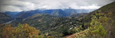 |
| Coroico Valley |
The weather was pretty menacing so we decided not to fly, but we were more or less ready to go for the next day.
The next morning we walked early to the take off. The wind was good and a few birds were making their way up the slope. We had to go quickly as we heard that the valley wind could be very strong from 10-11 a.m. We struggled a bit to take off on a slope with a lot of vegetation, but finally got airborne. From the sky we could see the real take off, we just didn't walk far enough... Anyway I managed to climb a bit above the village. It was nice to be in the air again. First Bolivian flight!
 |
| Coroico |
But quite quickly (as predicted) the wind came in strong and we had to make our way to the bottom of the valley. I struggled to make progress and the air was pretty turbulent on landing, but all good. Geo was a bit behind me and he got even stronger conditions on landing making out for a good learning of the valley breeze system.
 |
| Landing in the river bed |
After some hesitation we decided to stay a bit longer there as there was some good hiking potential and it was possible to fly. The decisive factor was also that we found a cheap hostel including a terrace with a beautiful view of the valley. Terrific spot for reading!
 |
| Morning view from the terrace |
The next day we went to the same spot (but real take off this time). I had a good flight playing with the clouds, soaring over the village before it got strong again.
Straight after the flight we got back to the hotel and went on for a walk. We hiked passing by coca and coffee plantations. The region of the Yungas is famous for producing some of the finest chewing coca. Litteraly everybody there is chewing a ball of leaves. With one or two balls in the mouth people are quite funny looking, a bit of a hamster face.
 |
| Coca field |
We walked for about 4 hours at a good pace to get to the river bed. We took a bit of a longer way than the usual loop, but no pain no gain. The landscapes were really nice.
Finally after a refreshing storm we got to the river, but there, no way to carry on. Coming back the way we came was not an option, way too long and about 1000m to climb up! So we decided to make our way straight through the river bed. Quite tricky at times with a lot of current but a lot of fun.
 |
| Walking on water |
We managed to make our way through the valley using the river then climbed back up to the village. A good 6 hours walk after a flight in the morning. An action packed day that deserved a little beer on the terrace for a perfect ending.
Bonus Pics:
 |
| HAPPINESS |


Aucun commentaire:
Enregistrer un commentaire